Kohima Travel Guide:
Introduction
Kohima is the hilly capital of India's north eastern border state of Nagaland which shares its borders with Burma. It lies in Kohima District and is also one of the three Nagaland towns with Municipal council status along with Dimapur and Mokokchung.
Kohima is so called because the Britisher could not pronounce "kewhira"(the name of the village). "Kew Hi Ra" means "the land where all travellers are welcome". Earlier, Kohima was known as "Thigoma"
History
The British incursions into the Naga territory beginning in the 1840s met with stiff resistance from the independence loving Nagas who had never been conquered by any empire before. The stiffness of the resistance can be gauged by the fact that it took nearly four decades for the British to conquer a territory that is less than 10,000 square kilometres (the eastern region was left free). Kohima was the first seat of modern administration as the Headquarters of Naga Hills District (then under Assam) with the appointment of G.H. Damant as Political Officer in 1879. When Nagaland became a full fledged state on 1 December 1963, Kohima was christened as the state capital.
In 1944 during World War II the Battle of Kohima along with the simultaneous Battle of Imphal was the turning point in the Burma Campaign. For the first time in South-East Asia the Japanese lost the initiative to the Allies which they then retained until the end of the war. This hand-to-hand battle and slaughter prevented the Japanese from gaining a high base from which they might next roll across the extensive flatlands of India like a juggernaut.
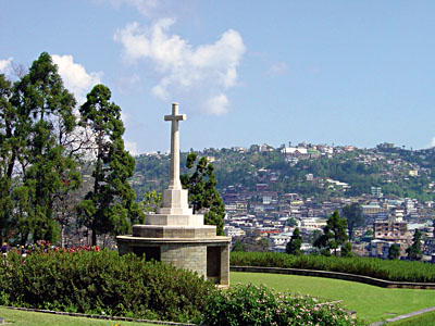
Kohima has a large cemetery for the Allied war dead maintained by the Commonwealth War Graves Commission. The cemetery lies on the slopes of Garrison Hill, in what was once the Deputy Commissioner's tennis court which was the scene of intense fighting, the Battle of the Tennis Court. The epitaph carved on the memorial of the 2nd British Division in the cemetery
Demographics
As of 2001[update] India census, Kohima had a population of 78,584. Males constitute 53% of the population and females 47%. Kohima has an average literacy rate of 75%, higher than the national average of 59.5%: male literacy is 79%, and female literacy is 70%. In Kohima, 13% of the population is under 6 years of age.
The main indigenous inhabitants of Kohima district are the Angami Nagas, and the Rengma.
Today the town's population compose of all the 16 tribes of Nagaland. The population of the Angamis and Aos are the largest in present day Kohima urban area.
Greater Kohima which includes Kohima Village, Jakhama and Jotsoma along with Kohima town is the second largest urban area of Nagaland after Dimapur-Chumukedima. It has a population of about 99,795.
Geography
Kohima is located at 25°40'N 94°07'E? / ?25.67°N 94.12°E? / 25.67; 94.12.[4] It has an average elevation of 1261 metres (4137 feet).
Localities
Colonies in Kohima (officially recognised as well as non-recognised ones)
* Kohima Town
* Mission Compound
* Pezielietsie(Tinpati)
* Krouliezou
* Science College
* Ministers' Hill (Old and New)
* Forest Colony
* Jail Colony
* Agri Colony
* Para Medical
* Hospital Colony
* New Market
* Naga Bazaar
* Dak Lane
* Kitsubozou
* Seikhazou Colony
* Bayavü Hill(Upper,Middle & Lower)
* Government High School Colony
* Rokabozou
* Keziekie
* Porter Lane
* Chandmari Colony (Upper and Lower)
* A.G. Colony (Upper and Lower)
* Lerie Colony
* New Reserve Colony
* Aradhura Colony
* Mohon Khola
* BOC
* Dzüvürü
* P.R.Hill
* Kenuozou Hill Colony (Upper and Lower)
* PWD Colony (Upper,Middle & Lower)