Coorg Travel Guide:
Introduction
Kodagu is an administrative district in Karnataka State in southern India. It is also known by its anglicised former name of Coorg. It occupies an area of 4,102 square kilometres (1,584 sq mi) of land in the Western Ghats of southwestern Karnataka. As of 2001, the population was 548,561, with some 13.74% of the population residing in the district's urban centres.
Madikeri is the headquarters of the Kodagu district. The district is bordered by Dakshina Kannada district to the northwest, Hassan district to the north, Mysore district to the east, the Kannur District of Kerala to the southwest, and the Wayanad District of Kerala to the south.
Geography
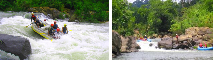
Kodagu is located on the eastern slopes of the Western Ghats. It has a geographical area of 4,102 km2 (1,584 sq mi).[2] The district is bordered by Dakshina Kannada district to the northwest, Hassan district to the north, Mysore district to the east, the Kannur District of Kerala to the southwest, and the Wayanad District of Kerala to the south. It is a hilly district with the lowest elevation in the district at 900 metres (3,000 ft) above sea-level. The highest peak, Tadiandamol, rises to 1,750 metres (5,740 ft), with Pushpagiri, the second highest, at 1,715 metres (5,627 ft). The main river in Kodagu is the Kaveri (Cauvery). The Kaveri starts at Talakaveri, located on the eastern side of the Western Ghats, and with its tributaries, drains the greater part of Kodagu.
In July and August, rainfall is intense, and there are often showers into November. Yearly rainfall may exceed 4,000 millimetres (160 in) in some areas. In dense jungle tracts, rainfall reaches 3,000 to 3,800 millimetres (120 to 150 in) and 1,500 to 2,500 millimetres (59 to 98 in) in the bamboo district to the west. Kodagu has an average temperature of 15 °C (59 °F), ranging from 11 to 28 °C (52 to 82 °F), with the highest temperatures occurring in April and May. The principal town, and district capital, is Madikeri, or Mercara, with a population of around 30,000. Other significant towns include Virajpet (Virarajendrapet), Kushalnagar, and Somwarpet. The district is divided into the three administrative talukas (divisions) of Madikeri, Virajpet and Somwarpet..
Agriculture
Much of the district is cultivated: characteristically and historically, paddy fields are found on the valley floors, with agroforestry in the surrounding hills. Ginger crops and meadows can also be found in the valley. The most common plantation crop is coffee, especially Coffea robusta variety. Kodagu is the first coffee production region in India. The Coffea arabica variety is also grown in some parts of southern and western Kodagu, the historical area of coffee production. The coffee agro-forestry systems of Kodagu are one of the richest [agroforest] in the world, with about 270 species of shaded trees inventoried (see publications of CAFNET project). But the trend is now to replace the native shade trees by exotic ones (i.e. Grevillea robusta). In those coffee agro-forests are also cultivated spices like black pepper, cardamon, vanilla. Coorg is also famous for its forest honey.
Many other crops are also cultivated, including para rubber, teak, and cocoa. There are also large areas of natural forest, especially in the forest reserves in the south and east.
Festivals of Kodagu
Kailpodhu is celebrated on 3 September. Officially, the festival begins on the 18th day after the sun enters the Simha Raasi (the Western sign of Leo). Kail means weapon or armory and Pold means festival. The day signifies the completion of "nati" - meaning the transplantation of the rice (paddy) crop.
The festival signifies the day when men should prepare to guard their crop from wild boars and other animals, since during the preceding months, in which the family were engaged in the fields, all weapons were normally deposited in the "Kanni Kombare", or the prayer room. Hence on the day of Kailpoldu, the weapons are taken out of the Pooja room, cleaned and decorated with flowers. They are then kept in the "Nellakki Nadubadec", the central hall of the house and the place of community worship. Each member of the family has a bath, after which they worship the weapons, afterwards feasting and drinking follow. The eldest member of the family hands a gun to the senior member of the family, signifying the commencement of the festivities. The whole family assembles in the "Mand" (open ground), where physical contests and sports, including marksmanship, are conducted. In the past the hunting and cooking of wild game was part of the celebration, but today shooting skills are tested by firing at a coconut tied onto the branch of a tall tree.
Traditional rural sports, like grabbing a coconut from the hands of a group of 8-10 people (thenge porata), throwing a stone the size of a cricket ball at a coconut from a distance of 10-15 paces (thenge eed), lifting a stone ball of 30–40 cm lying at one's feet and throwing it backwards over the shoulders, etc., are now conducted in community groups called Gowda Samajas & Kodava Samajas in towns and cities.
Transport
oad: There is a good set of road connections to the east and west.Tellicheery-Coorg road links Kodagu to Malabar region of the neighbouring state Kerala
Rail: The nearest railway stations are Thalassery,Mysore and Hassan.
Air: The nearest airport is Mysore Airport which is 90 KM away and Mangalore International Airport around 180 km away.Kannur International Airport at Mattannoor in Kerala,expected to be completed in 2012, is 55 Kms away from Virajpet.