Munnar Travel Guide:
Introduction
Munnar is one of the most popular hill-resort towns in Kerala and in southern India. Munnar is located on the Western Ghats, situated in the Idukki district.
The name Munnar is believed to be derived from the Malayalam/Tamil words Munu (three) and aaru (river), referring to the town's strategic location at the confluence of the Muthirappuzha, Nallathanni and Kundaly rivers.
The Munnar panchayat in the Devikulam block is the largest panchayat in the Idukki district having an area measuring nearly 557 km².
The nearest major railway stations are at Ernakulam and Aluva (approximately 110km by road). The nearest airport is Cochin International Airport, which is 105km away.
Geography and climate
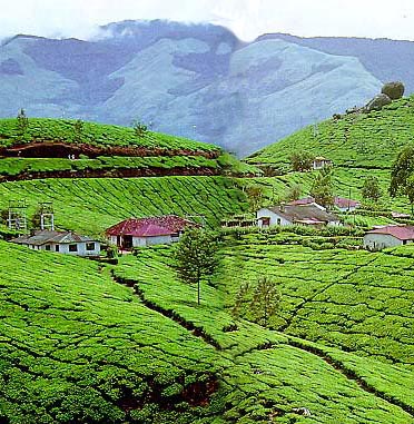
The region in and around Munnar varies in height from 2,000 meters (6,562 ft) to 2,600 meters (8,530 ft) above mean sea level. Munnar enjoys a salubrious climate. The temperature ranges between 10 °C (50 °F) and 0 °C (32 °F) in winter and 8 °C (46.4 °F) and 16 °C (60.8 °F) in summer. The tourist season in Munnar is from August to May. However, even the monsoons are lovely with many streams and rivulets in the area and post drizzle the dew drenched tea gardens looking majestic and heavenly enshrouded in light mist . See:map
Eravikulam National Park
Located about 15 km from Munnar, this park is famous for its endangered inhabitant - the Nilgiri Tahr. Spread over an area of 97 sq. km., this park is also home to several species of rare butterflies, animals and birds. A great place for trekking, the park offers a magnificent view of the tea plantations and also the rolling hills caressed by blankets of mists. The park becomes a hot destination when the hill slopes here get covered in a carpet of blue, resulting from the flowering of Neelakurinji. It is a plant endemic to this part of the Western Ghats which blooms once in twelve years. The last time it bloomed was in 2006.
Top Station
Top Station, which is about 27 km from Munnar is at a height of 1700 m above sea level. It is the highest point on the Munnar-Kodaikanal road. Travellers to Munnar make it a point to visit Top Station to enjoy the panoramic view it offers of the neighboring state of Tamil Nadu. It is one of the spots in Munnar to enjoy the Neelakurunji flowers blooming over a vast area.
Tea Museum
Munnar has a legacy of its own when to comes to the origins and evolution of tea plantations. Taking account of this legacy and to preserve and showcase some of the exquisite and interesting aspects on the genesis and growth of tea plantations in Kerala's high ranges, a museum exclusively for tea was opened some years ago by Tata Tea in Munnar. This Tea Museum houses curios, photographs and machineries; all of which have a story to tell on the origins and growth of tea plantation in Munnar. The museum is located at the Nallathanni Estate of Tata Tea in Munnar and is worth a visit.
Flora and fauna
Most of the native flora and fauna of Munnar have disappeared due to severe habitat fragmentation resultant from the creation of the plantations. However, some species continue to survive and thrive in several protected areas nearby, including the new Kurinjimala Sanctuary to the east, the Chinnar Wildlife Sanctuary, Manjampatti Valley and the Amaravati reserve forest of Indira Gandhi Wildlife Sanctuary to the north east, the Eravikulam National Park and Anamudi Shola National Park to the north, the Pampadum Shola National Park to the south and the proposed Palani Hills National Park to the east. These protected areas are especially known for several threatened and endemic species including Nilgiri Thar, the Grizzled Giant Squirrel, the Nilgiri Wood-pigeon, Elephant, the Gaur, the Sambar, and the Neelakurinji (that flowers once in twelve years).