Himachal Travel Guide:
Introduction
Himachal Pradesh is a state in Northern India. It is spread over 21,495 sq mi (55,673 km²), and is bordered by the Indian states of Jammu and Kashmir on the north, Punjab on the west and south-west, Haryana and Uttar Pradesh on the south, Uttarakhand on the south-east and by the Tibet Autonomous Region on the east. The literal meaning of Himachal Pradesh is Region of snowy mountains.
Himachal Pradesh was anciently known as Dev Bhumi (The Abode of Gods) and is abundance in natural beauty After the Anglo Gorkha War, the British colonial government came into power. It was initially part of Punjab, except the Siba State of Punjab Hills which was under the rule of Maharaja Ranjit Singh until 1857. In 1950 Himachal was declared as a union territory but after the State of Himachal Pradesh Act 1971, Himachal emerged as the 18th state of the Indian Union. Himachal has many prestigious boarding schools. Hima means snow in Sanskrit. It was named by one of the great Sanskrit scholars of Himachal Pradesh, Acharya Diwakar Datt Sharma
Himachal Pradesh has one of the highest per capita incomes of any state in India. Due to the abundance of perennial rivers, Himachal also sells hydro electricity to other states such as Delhi, Punjab and Rajasthan. The economy of the state is highly dependent on three sources: hydroelectric power, tourism and agriculture.
Hindus make up 95% of the state population, making it the most Hindu state (proportionally), in India. According to a 2005 Transparency International survey, Himachal Pradesh is ranked the second-least corrupt state in the country after Kerala.[1
History
The history of the area that now constitutes Himachal Pradesh dates back to the time when the Indus valley civilisation flourished between 2250 and 1750 BCE. Tribes such as the Koilis, Halis, Dagis, Dhaugris, Dasa, Khasas, Kinnars and Kirats inhabited the region from pre-histotic era. During the Vedic period, several small republics known as "Janapada" existed which were later conquered by the Gupta Empire. After a brief period of supremacy by king Harshavardhana, the region was once again divided into several local powers headed by chieftains, including some Rajput principalities. These kingdoms that enjoyed a large degree of independence were devastated by Muslim invaders a number of times. Mahmud Ghaznavi conquered Kangra at the beginning of the 10th century. Timur and Sikander Lodi also marched through the lower hills of the state and captured a number of forts and fought many battles. Several hill states acknowledged Mughal suzerainty and paid regular tribute to the Mughals
The Gorkhas, a martial tribe came to power in Nepal in the year 1768. They consolidated their military power and began to expand their territory.[11] Gradually the Gorkhas annexed Sirmour and Shimla. With the leadership of Amar Singh Thapa, Gorkhas laid siege to Kangra. They managed to defeat Sansar Chand, the ruler of Kangra, in 1806 with the help of many provincial chiefs. However Gorkhas could not capture Kangra fort which came under Maharaja Ranjeet Singh in 1809. After the defeat the Gorkhas began to expand towards the south of the state. However, Raja Ram Singh, Raja of Siba State re-captured the fort of Siba from the army of Maharaja Ranjit Singh in Samvat 1846, during the First Anglo-Sikh War. They came into direct conflict with the British along the tarai belt after which the British expelled them from the provinces of the Satluj. Thus the British gradually emerged as the paramount powers.[11] The revolt of 1857 or first Indian war of independence resulted due to the building up of political, social, economic, religious and military grievances against the British government. People of the hill states were not as politically active as the people in other parts of the country. They remained more or less inactive and so did their rulers, with the exception of Bushahr. Some of them even rendered help to the British government during the revolt. Among them were the rulers of Chamba, Bilaspur, Bhagal and Dhami. The rulers of Bushars rather acted in a manner hostile to the interests of British.
The British territories in the hill came under British Crown after Queen Victoria's proclamation of 1858. The states of Chamba, Mandi and Bilaspur made good progress in many fields during the British rule. During World War I, virtually all rulers of the hill states remained loyal and contributed to the British war effort both in the form of men and materials. Amongst these were the states of Kangra, Jaswan, Datarpur, Guler, Nurpur, Chamba, Suket, Mandi and Bilaspur
Geography and climate
Himachal is situated in the western Himalayas. Covering an area of 55,673 kilometres (34,594 mi), Himachal Pradesh is a mountainous state with elevation ranging from about 350 metres (1,148 ft) to 7,000 metres (22,966 ft) above the sea level.
Lahaul, Himachal Pradesh.
The drainage system of Himachal is composed both of rivers and glaciers. Himalayan rivers criss-cross the entire mountain chain. In fact the rivers are older than the mountain system. Himachal Pradesh provides water to both the Indus and Ganges basins. The drainage systems of the region are the Chandra Bhaga or the Chenab, the Ravi, the Beas, the Sutlej and the Yamuna. These rivers are perennial and are fed by snow and rainfall. They are protected by an extensive cover of natural vegetation.
There is great variation in the climatic conditions of Himachal due to extreme variation in elevation. The climate varies from hot and sub-humid tropical in the southern tracts to cold, alpine and glacial in the northern and eastern mountain ranges with more elevation. The state has areas like Dharamsala that receive very heavy rainfall, as well as those like Lahaul and Spiti that are cold and almost rainless. Broadly Himachal experience three seasons; hot weather season, cold weather season and rainy season. Summer lasts from mid April till the end of June and most parts become very hot (except in alpine zone which experience mild summer) with the average temperature ranging from 28 °C (82 °F) to 32 °C (90 °F). Winter lasts from late November till mid March. Snowfall is common in alpine tracts (generally above 2,200 metres (7,218 ft) i.e. in the Higher and Trans-Himalayan region).
Transport
Roads are the major mode of transport in the hilly terrains of Himachal Pradesh. The state has road network of 28,208 km (17,528 mi), including eight national highways (NH) that constitute 1,234 km (767 mi). Some roads get closed during winter and monsoon seasons due to snowfall and landslides. Regular bus services connect Shimla with Chandigarh, Kullu, Manali, Delhi, Mandi, Pathankot, Ambala, Chail and Dehradun. Local taxis are the major local transport here. District Hamirpur has got the highest road density in the country.
Railway track is accessible only to a few places in Himachal Pradesh. The Pathankot–Jogindernagar line connects Punjab with Himachal Pradesh. The other railway tracks pass through Shimla, Solan and Una. Shimla is connected with Kalka by a narrow gauge railway line, which in turn is connected with the major cities in India. Himachal has two narrow gauge rail tracks. The Kalka-Shimla Railway track has a length of 96 kilometres. It passes through 102 tunnels and crosses 864 bridges.
There are three domestic airports in the state—Shimla Airport, Bhuntar Airport serving Kullu and Manali, and Gaggal Airport serving Kangra and Dharamsala. The air routes connect the state with Delhi and Chandigarh. There are no international airports in Himachal Pradesh. Deccan, Air India, MDLR has flights from Delhi, Chandigarh to Kullu and back. Jagson Airlines has flights from Delhi to Shimla.
Culture
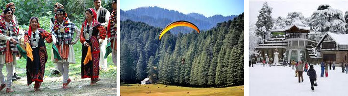
Himachal was one of the few states that had remained largely untouched by external customs, largely due to its difficult terrain. With the technological advancements the state has changed very rapidly. It is a multireligional, multicultural as well as multilingual state like other Indian states. Some of the most commonly spoken languages includes Hindi, Pahari, Dogri, Mandialli Kangri, Gojri and Kinnauri. The caste communities residing in Himachal include the Brahmins, Rajputs, Gujjars, Gaddis, "Grith (choudhary)," Kannets (come under RAJPUTS), Rathis and Kolis. There are also tribal population in the state which mainly comprise , Kinnars,Pangawals, Sulehria, and Lahaulis.
The state is well known for its handicrafts. The carpets, leather works, shawls, metalware, woodwork and paintings are worth appreciating. Pashmina shawl is one of the product which is highly in demand not only in Himachal but all over the country. Himachali caps are also famous art work of the people. Extreme cold winters of Himachal necessitated wool weaving. Nearly every household in Himachal owns a pit-loom. Wool is also considered as pure and is used as a ritual cloth. The well known woven object is the shawl, ranging from fine pashmina to the coarse desar. Kullu is famous for its shawls with striking patterns and vibrant colours. Kangra and Dharamshala are famous for Kangra miniature paintings.
Local music and dance reflects the cultural identity of the state. Through their dance and music, they entreat their gods during local festivals and other special occasions. Apart from the fairs and festivals that are celebrated all over India, there are number of other fairs and festivals also that are of great significance to Himachal Pradesh.