Gangtok Travel Guide:
Introduction
Gangtok is the capital and largest town of the Indian state of Sikkim. Gangtok is located in the Shivalik Hills of the eastern Himalayan range, at an altitude of 1,437 metres (4,715 ft). The town, with a population of thirty thousand belonging to different ethnicities such as Nepalis, Lepchas and Bhutia, is administered by various departments of the Government of Sikkim. Nestled within higher peaks of the Himalaya and enjoying a year-round mild temperate climate, Gangtok is at the centre of Sikkim’s tourism industry.
Gangtok rose to prominence as a popular Buddhist pilgrimage site after the construction of the Enchey Monastery in 1840. In 1894, the ruling Sikkimese Chogyal, Thutob Namgyal, transferred the capital to Gangtok. In the early 20th century, Gangtok became a major stopover on the trade route between Lhasa in Tibet and cities such as Kolkata (then Calcutta) in British India. After India won its independence from Britain in 1947, Sikkim chose to remain an independent monarchy, with Gangtok as its capital. In 1975, after the integration with the union of India, Gangtok was made India's twenty-second state capital.
The precise meaning of the name Gangtok is unclear, though the most popular meaning is "hill top". Today, Gangtok is a centre of Tibetan Buddhist culture and learning, with the presence of several monasteries, religious educational institutions, and centres for Tibetology.
History
Like the rest of Sikkim, not much is known about the early history of Gangtok. he earliest records date from the construction of the hermitic Gangtok monastery in 1716. Gangtok remained a small hamlet until the construction of the Enchey Monastery in 1840 made it a pilgrimage center. It became the capital of what was left of Sikkim after an English conquest in mid 19th century in response to a hostage crisis. After the defeat of the Tibetans by the British, Gangtok became a major stopover in the trade between Tibet and British India at the end of the 19th century. Most of the roads and the telegraph in the area were built during this time.
In 1894, Thutob Namgyal, the Sikkimese monarch under British rule, shifted the capital from Tumlong to Gangtok, increasing the city's importance. A new grand palace along with other state buildings was built in the new capital. Following India's independence in 1947, Sikkim became a nation-state with Gangtok as its capital. Sikkim became a suzerain of India, with the condition that it would retain its independence, by the treaty signed between the Chogyal and the then Indian Prime Minister Jawaharlal Nehru. This pact gave the Indians control of external affairs on behalf of Sikkimese. Trade between India and Tibet continued to flourish through the Nathula and Jelepla passes, offshoots of the ancient Silk Road near Gangtok. These border passes were sealed after the Sino-Indian War in 1962, which deprived Gangtok of its trading business.The Nathula pass was finally opened for limited trade in 2006, fuelling hopes of economic boom.
In 1975, after years of political uncertainty and struggle, including riots, the monarchy was abrogated and Sikkim became India's twenty-second state, with Gangtok as its capital after a referendum. Gangtok has witnessed annual landslides, resulting in loss of life and damage to property. The largest disaster occurred in June 1997, when 38 were killed and hundreds of buildings were destroyed.
Geography
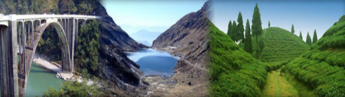
Gangtok is located at 27°20'N 88°37'E? / ?27.33°N 88.62°E? / 27.33; 88.62.It is situated in the lower Himalayas at an altitude of 5,500 ft (1,676 m). In addition to being the state capital, it is the headquarters of the East Sikkim district. The town lies on one side of a hill, with "The Ridge", a promenade housing the governor's residence, at one end and the palace, situated at an altitude of about 6,000 ft (1,829 m), at the other. The city is flanked on east and west by two streams, namely Roro Chu and Ranikhola, respectively. These two rivers divide the natural drainage into two parts, the eastern and western parts. Both the streams meet the Ranipul and flow south as the main Ranikhola before it joins the Teesta at Singtam.Most of the roads are steep, with the buildings built on compacted ground alongside them.
Most of Sikkim, including Gangtok, is underlain by Precambrian rock which contains foliated phyllites and schists; slopes are therefore prone to frequent landslides.[dead link] Surface runoff of water by natural streams (jhora) and man-made drains has contributed to the risk of landslides.[dead link] According to the Bureau of Indian Standards, the town falls under seismic zone-IV (on a scale of I to V, in order of increasing seismic activity), near the convergent boundary of the Indian and the Eurasian tectonic plates and is subject to frequent earthquakes. The hills are nestled within higher peaks and the snow-clad Himalayan ranges tower over the town from the distance. Mount Kanchenjunga (8,598 m or 28,208 ft)—the world's third-highest peak—is visible to the west of the city. The existence of steep slopes, vulnerability to landslides, large forest cover and inadequate access to most areas has been a major impediment to the natural and balanced growth of the city.[dead link]
There are densely forested regions around Gangtok, consisting of temperate, deciduous forests of poplar, birch, oak, and elm, as well as evergreen, coniferous trees of the wet alpine zone.[dead link] Orchids are common, and rare varieties of orchids are featured in flower shows in the city. Bamboos are also abundant. In the lower reaches of the town, the vegetation gradually changes from alpine to temperate deciduous and subtropical.[dead link] Flowers such as sunflower, marigold, poinsettia, and others bloom, especially in November and December.
Utility services
Electricity is supplied by the power department of the Government of Sikkim. Gangtok has a nearly uninterrupted electricity supply due to Sikkim's numerous hydroelectric power stations. The rural roads around Gangtok are maintained by the Border Roads Organisation, a division of the Indian army. Several roads in Gangtok are reported to be in a poor condition,whereas building construction activities continue almost unrestrained in this city lacking proper land infrastructure.Most households are supplied by the central water system maintained and operated by the PHED.The main source of PHED water supply is the Rateychu River, located about 16 km (9.9 mi) from the city, at an altitude of 2,621 m (8,599 ft). Its water treatment plant is located at Selep. The river Rateychu is snow-fed and has perennial streams. Since there is no habitation in the catchment area except for a small army settlement, there is little environmental degradation and the water is of very good quality. 40 seasonal local springs are used by the Rural Management and Development Department of Sikkim Government to supply water to outlying rural areas.
Transport
Taxis are the most widely available public transport within Gangtok. Most of the residents stay within a few kilometres of the town centre and many have their own vehicles such as two-wheelers and cars. The share of personal vehicles and taxis combined is 98% of Gangtok's total vehicles, a high percentage when compared to other Indian cities.[dead link] City buses comprise less than one percent of vehicles.[dead link] Those travelling longer distances generally make use of share-jeeps, a kind of public taxis. Four wheel drives are used to easily navigate the steep slopes of the roads. The 1 km (0.6 mi) long cable car with three stops connects lower Gangtok suburbs with Sikkim Legislative assembly in central Gangtok and the upper suburbs.
Education
Gangtok's schools are either run by the state government or by private and religious organizations. Schools mainly use English and Nepali as their medium of instruction. The schools are either affiliated with the Indian Certificate of Secondary Education, Central Board of Secondary Education or the National Institute of Open Schooling. Notable schools include the Tashi Namgyal Academy, Paljor Namgyal Girls School and Kendriya Vidyalaya.Colleges conferring graduate degrees include Sikkim Government College, Sikkim Government Law College and Damber Singh College. Gangtok does not have a university within the city limits. However, 8 km (5.0 mi) from here is the headquarters of the Sikkim Manipal University, which houses Sikkim Manipal Institute of Medical Sciences and Manipal Institute of Technology.There are other institutions offering diplomas in Buddhist literature, catering and other non-mainstream fields. District Institute of Education and Training and State Institute of Education conduct teacher training programs. Students usually go to large cities in the vicinity such as Siliguri or Kolkata in pursuit of higher education.
Media
More than 50 newspapers are published in Sikkim, most of them in Gangtok.Multiple local Nepali and English newspapers are published, whereas regional and national Hindi and English newspapers, printed elsewhere in India, are also circulated. The English newspapers include The Statesman and The Telegraph, which are printed in Siliguri; The Hindu and The Times of India, which are printed in Kolkata. Sikkim Herald, the newsweekly of the Government of Sikkim is published in thirteen languages of the state.
Gangtok has two cinema halls featuring Nepali, Hindi and English language films. The town also has a public library.There are Internet cafés in and around the city, but broadband connectivity is limited. Satellite dishes exist in most homes in the region and the channels available throughout India are also available here, along with a few Nepali language channels. The main service providers are Sikkim Cable, Nayuma, Dish TV and Doordarshan. The national All India Radio along with two fm stations Nine fm and Radio Misty are the three radio stations in the city. BSNL, Reliance and Airtel have the three largest cellular networks in the town. There is a Doordarshan TV tower in Gangtok