Chamba Travel Guide:
Introduction
Chamba is an ancient town in the Chamba district in the state of Himachal Pradesh, in northern India. According to the 2001 Indian census, Chamba has a population of 38,312 people. Located at an altitude of 996 metres (3,268 ft) above mean sea level, the town is situated on the banks of the Ravi River (a major tributary of the Trans-Himalayan Indus River), at its confluence with the Sal River.
Though historical records date the history of the Chamba region to the Kolian tribes in the 2nd century BC, the area was formally ruled by the Maru dynasty, starting with the Raju Maru from around 500 AD, ruling from the ancient capital of Bharmour, which is located 75 kilometres (47 mi) from the town of Chamba. In 920, Raja Sahil Varman (or Raja Sahil Verma) shifted the capital of the kingdom to Chamba, following the specific request of his daughter Champavati (Chamba was named after her). From the time of Raju Maru, 67 Rajas of this dynasty have ruled over Chamba until it finally merged with the Indian Union in April 1948, although Chamba was under British suzerainty from 1846 to this time.
The town has a large number of temples and palaces, and hosts two popular jatras (fairs), the "Suhi Mata Mela" and the "Minjar Mela", which last for several days and involve music and dancing. Chamba is also well noted for its arts and crafts, particularly its Pahari paintings, which originated in the Hill Kingdoms of North India between the 17th and 19th century and its handicrafts and textiles
Modern history
By the late 18th century, the Sikhs under Maharaja Ranjit Singh controlled the region and had even placed a garrison at Chamba, forced the hill states to pay tribute to them. Ranjit Singh deposed the hill princes, including the more powerful Kangra ruler, Sansar Chand Katoch, but spared Chamba, given that the Wazir Nathu of Chamba had been important as an ambassador in negotiations with Katoch in 1809 and had saved his life in 1817 by succumbing his horse to King Singh to escape during a winter campaign in Kashmir. After Ranjit Singh’s death, Chamba became unprotected and was drawn into the vortex of the disintegration of the Sikh Kingdom.
The Chamba Valley, c. 1865
In 1845, the Sikh army invaded the British territory. The result was disastrous, with the British defeating the army, leaving Chamba in a poor position. Wazir Bagha of Chamba was important in negotiations in its aftermath, and the Rajas of Chamba, upon on the advice of Bagha, agreed to the British suzerainty as part of Jammu and Kashmir in favour of an annuity of Rs 12,000. The Treaty of Lahore was signed in 1846, in which the Rajas agreed to ceding the territory of Chamba district. From then on, relations with the British were cordial, and the all of the Rajas of Chamba under the British rule, Sri Singh, Gopal Singh, Sham Singh, Bhuri Singh, Ram Singh and Laxman Singh were on good terms with the British army officers.
Many progressive reforms and developments were made in Chamba under the British.[8] In 1863, the first Post office was established in Chamba and a daily mail service and a primary school. In December, 1866, a hospital was opened by Doctor Elmslie of the Kashmir Medical Mission.[15] In the late 1860s two new roads to Dalhousie via Kolri and Khajiar were built. Gopal Singh, who ruled from 1870 to 1873, after abdicating, was responsible for building the grand Jandarighat Palace as his summer residence.
Subsequent to India becoming an independent nation in August 1947, the princely state of Chamba finally merged with India on April 15, 1948 along with the other princedoms of Mandi-Suket, Sirmour and all of those in the Shimla hills
Geography and climate
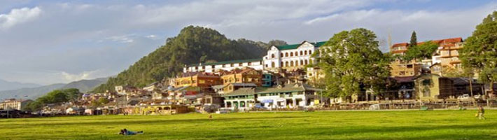
Chamba is the headquarters of the Chamba district, bordered by Jammu and Kashmir to the north-west and west, the Ladakh area of Jammu and Kashmir and Lahaul and Bara Banghal to the north-east and east, Kangra to the south-east and Gurdaspur district of Punjab to the south. It has an average elevation of 1,006 metres (3,301 ft).The Ravi River flowing through Chamba
The town, the district and the valley where the town is located, share the name of Chamba. The town of Chamba is located at the junction of Ravi River and its tributary, the Sal River, with the Shah Madar hill forming the backdrop on its eastern side. The Ravi flows in east-west direction forming deep canyons. During the spring and summer months, the levels of the river rise significantly from snow melt and pose a flooding risk. Record levels were experienced in early July 2005, when the National Hydroelectric Power Corporation was forced to shut down the power generation on its 300-MW Chamera Power Station.
Located on the right bank of the Ravi river valley, built on successive flat terraces, the town is bounded topographically by the Dhauladhar and Zanskar ranges, south of the inner Himalayas. Chamba, despite its hill location, is well connected by road to the rest of the state and country, including Shimla, Delhi and Chandigarh along several routes. The nearest broad gauge railway stations are at Chakki Bank and Pathankot, the latter of which is 120 kilometres (75 mi) away by road.
The temperatures in summer vary between 38 °C (100 °F) and 15 °C (59 °F) and in winter: 15 °C (59 °F) and 0 °C (32 °F).[20] The maximum temperature recorded in summer is 39 °C (102 °F) and the minimum temperature in winter is -1 °C (30.2 °F). Climatically March to June is said to be the best period to visit Chamba, which is a well known hill station.[20] The average annual rainfall in the town is 785.84 millimetres (30.939 in)
Monuments built prior to 1846
Buildings in Chamba were traditionally constructed using local materials. Buildings were made out of dry stone masonry, with the walls and floors of the older houses plastered with a concoction of clay and cow-dung. Thick wooden beams were used to support the walls, paying attention to durability and to withstand earthquakes, and wooden cantilever construction was often used to support the verandas. The staircases and doors were made from wood, with the doors often decorated in religious reliefs and flanked by two lamps to light it at night. Before the arrival of the British, who introduced slate roofs to Chamba, roofs were covered with planks, coated in clay. Few of these houses remiain today, although a number still have wood-clay roofs in villages in the suburbs.
The old heritage monuments, which comprise of palaces and temples are located in the old town (east of the Chaugans), on the lower slopes of Shah Madar hill. They were built in the lower valley where the two rivers and steep thickly forested hillsides provided a strong defense. Located here is the 10th century Champavati Temple, said to have marked the birth of the town, the Lakshmi Narayan group of temples (built from 10th-19th century), the 10th century Sita Ram Temple, Bansi Gopal temple, Kharura Mohalla and Hari Rai temple, the 11th century Sui Mata Temple and Chamunda Devi Temple, and the Akhand Chandi palace, overlooking the Chaugan, which has since been converted in to a college. Additions were made to the palace in the form of the Zenana Mahal and the Rang Mahal in the 18th century. The temples built in Chamba demonstrate a strong Kashmiri influence with their stone temple architecture and temple iconography. Given their age however, only their unicellular layout with fluted pillars has been retained.